Unit 10 Longitude
 知识点一:Text Analysis: Longitude
I. Warming up
Watch the video and get to know our earth
Name the lines now.
1. Axis of the earth
2. North Pole
3. Arctic Circle
4. Tropic of Cancer
5. Equator
6. Tropic of Capricorn
7. Antarctic Circle
8. South pole
II. Background
Style:
Explaining a technical subject
The passage discusses some complex topics, such as navigation and mapmaking, for a general or non-scientific audience. To do this, the writer uses such devices as comparisons, examples, and extended explanations to make the material easier to understand.
III. Text analysis
Text Organization:
Discussion:
Work in pairs. Look at the sentences from the passage and discuss whether they are formal or informal. If they are informal, identify which features they display.
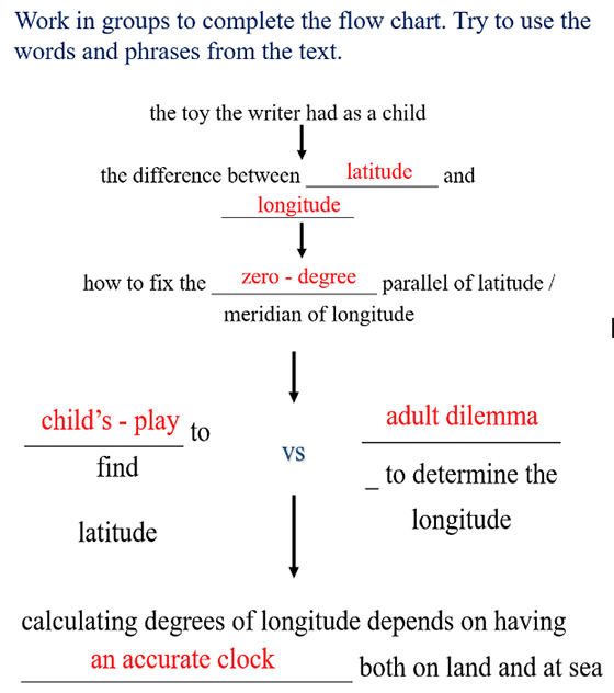
1. Why does the writer describe the toy she had as a child?
It eases us gently into the topic and gives us a clear visual image.
2. Why does the writer mention the statue of Atlas?
The writer is American and the reference would be helpful to many readers who know the statue of Atlas. The parallel between the girl on her father’s shoulders and the world on Atlas’ is amusing.
3. Why does the writer discuss Ptolemy and his prime meridian?
She wishes to tell us some of the history of the concepts of longitude and latitude. This builds up to the life of Ptolemy and shows how great his achievement was.
4. What is the voyage of Christopher Columbus an example of ?
Sailing with knowledge only of one’s latitude.
5. What does the writer refer to with “15 degrees”?
The apparent motion of the sun across the sky in one hour, and a distance travelled along the longitude lines.
6. Why does the writer mention da Gama, de Balboa, Magellan, and Drake?
These are famous explorers whose names are familiar in a general way among Western readers.
These early voyagers had to manage without being able to determine their longitude.
Paraphrase:
1. ... and national boundaries repeatedly redrawn by war and peace.
The borders of countries are changed by war and peace treaties.
2. Ptolemy himself has only an armchair appreciation of the wider world.
Ptolemy had never travelled. His information about the wider world came from books.
3. The zero-degree parallel of latitude is fixed by the laws of nature, while the zero-degree meridian of longitude shifts like the sands of time.
The Equator is an objectively calculated line; the prime meridian is a human convention and it has been moved about – at present by international agreement it goes through London, but it can be changed whenever nations wish. The sands of time means the passing of time, a metaphor based on the old timing device one turns upside down to measure a length of time.
4. … and turns the determination of longitude, especially at sea, into an adult dilemma – one that stumped the wisest minds of the world for the better part of human history.
… and makes it hard to determine the longitude, especially when people are taking navigation at sea. Stumped the wisest minds of the world means no one could solve it even though some clever people tried. If a problem stumps someone, they cannot think of a solution. For the better part of human history means for most of human history – indeed until it was solved in the late 18th century.
5. The measurement of longitude meridians, in comparison, is tempered by time.
Tempered by time means reliant on knowing the time. The word temper, which means to adjust musical pitch, is used metaphorically here.
6. … and turns the determination of longitude, especially at sea into an adult dilemma – one that stumped the wisest minds of the world for the better part of human history.
… and makes it hard to determine the longitude, especially when people are taking navigation at sea.
7. Ptolemy himself has only an armchair appreciation of the wider world.
Ptolemy had never travelled. His information about the wider world came from books.
Summary:
The latitude and longitude stay fixed as the world changes its ______________ underneath them. The latitude lines do stay ___________ to each other in a series of shrinking ____________ rings. The longitude lines loop from the North Pole to the South and back again in great circles of the _________ size. The zero-degree parallel of latitude is fixed by the ___________________. While the placement of the prime meridian is a purely ___________________. Longitude, a great aid to ocean navigators, is more _________ to calculate than latitude because the lines can be arbitrarily placed. In addition, calculating degrees of longitude depends on having an accurate_________ both on land and at sea.
Keys: configuration; parallel; concentric; same; laws of nature; political decision; difficult; clock.
IV. Reinforcement:
Discussion
(1) 1 What are some dangers for navigators in not being able to accurately judge longitude? Without a way of measuring longitude, sailors do not know where they are in the ocean and they might be sailing into dangerous waters far from where they actually want to be.
(2) What are some results of the explorers of the Age of Exploration sailing around the Earth? The decline of the land routes (such as the Silk Road) between the East and the West, the rise of the Eastern Atlantic states, the building of colonial empires in south-east Asia etc.
(3) Do you think many people today can work out directions without a map? For those who can, how do they do it? Some people use compasses. Of course, there are now GPS systems. Some people seem to have an inbuilt sense of direction.
(4) What other changes came about when people were able to make accurate, portable time pieces such as watches and small clocks? Time could be scheduled so appointments and fixed work hours became possible. Transport systems became far more efficient too.
请同学们继续学习